As stated in the December 21 log... "Our destination was a hike down to the Waipi'o (curving 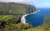 water) Valley, which starts where Highway 240 dead-ends. Actually, you can drive down a narrow, twisting road rated at a 25% incline. Steep, so 4-wheel drives are the rule. Our plan was to hike the road, but, well, rain. And the view from the adjacent lookout is supposed to be amazing with waterfalls plunging down 2,000 ft. cliffs. Another day." The sun was out and that day was December 27. water) Valley, which starts where Highway 240 dead-ends. Actually, you can drive down a narrow, twisting road rated at a 25% incline. Steep, so 4-wheel drives are the rule. Our plan was to hike the road, but, well, rain. And the view from the adjacent lookout is supposed to be amazing with waterfalls plunging down 2,000 ft. cliffs. Another day." The sun was out and that day was December 27.
We picked up some lunch in Honokaa, packed it into my camera hip bag, and began our descent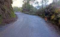 down the above-mentioned road. According to the guide book, the 25% grade road is "paved and thus not too strenuous," The book, however, does not mention wet asphalt with patches of slick, green moss. It took us 50 minutes to get to the bottom, as we picked spots in the road that were the least likely to cause loss of footing, holding on the side guard rail, AND sharing the road with 4-wheel drives going up and down. No, it was strenuous and a bit nerve-wracking as well. down the above-mentioned road. According to the guide book, the 25% grade road is "paved and thus not too strenuous," The book, however, does not mention wet asphalt with patches of slick, green moss. It took us 50 minutes to get to the bottom, as we picked spots in the road that were the least likely to cause loss of footing, holding on the side guard rail, AND sharing the road with 4-wheel drives going up and down. No, it was strenuous and a bit nerve-wracking as well.
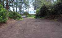 Once down in the valley, we followed a muddy, dirt road to the beach. Windy, rocky, but quite picturesque. We wanted to explore the beach on the other side of the Hi'ilawe stream, which "cleaves the valley floor towards the surf-fringed, boulder-strewn, black-sand beach", but decided against it, as we watched a man approach from the other side ford the stream up to his waist. So we headed back up the road to the junction that goes back up to the lookout or further back into the valley. We chose the latter, and it was a good thing. Once down in the valley, we followed a muddy, dirt road to the beach. Windy, rocky, but quite picturesque. We wanted to explore the beach on the other side of the Hi'ilawe stream, which "cleaves the valley floor towards the surf-fringed, boulder-strewn, black-sand beach", but decided against it, as we watched a man approach from the other side ford the stream up to his waist. So we headed back up the road to the junction that goes back up to the lookout or further back into the valley. We chose the latter, and it was a good thing.
Peggy was the first to round a corner in the road and exclaim, "Whoa!" Off in the distance, cascading down 1,400 ft. was the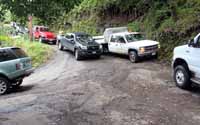 Hi'ilawe Falls, the state's tallest. According to the guidebook, hiking to the falls is "doable but challenging," as no trail officially exists. We continued to walk down the road, through a small residential area, until we reached a stream crossing the road... where we turned around and headed back to the junction and UP the road. Whew, steep, sweaty, but preferable to going down. Hi'ilawe Falls, the state's tallest. According to the guidebook, hiking to the falls is "doable but challenging," as no trail officially exists. We continued to walk down the road, through a small residential area, until we reached a stream crossing the road... where we turned around and headed back to the junction and UP the road. Whew, steep, sweaty, but preferable to going down.
Posted map of hike.
|