|
December 21, 2011
|
|
- - - - - - - - - - - - - -
|
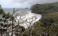
| More rain... wanted to drive down to Volcanoes National Park and do a hike, but was forecasted with a 90% chance of rain... so we drove north 'in the rain' to the northern part of the island with a 50% chance. Our destination was a hike down to the Waipi'o (curving water) Valley, which starts where Highway 240 dead-ends. Actually, you can drive down a narrow, twisting road rated at a 25% incline. Steep, so 4-wheel drives are the rule. Our plan was to hike the road, but, well, rain. And the view from the adjacent lookout is supposed to be amazing with waterfalls plunging down 2,000 ft. cliffs. Another day.
So it was back to Highway 19 to head northwest to Waimea, and then north on Highway 250. This route took us over over the Kohala After ascending (easier going up than down) the trail back to our car, we drove back to Hawi and had lunch at the Lighthouse Delicatessen. Excellent sandwich, so if you happen to be passing through, I highly recommend it. Heading east on Highway 270 takes you around the northern-most point of the island and |
| - - - - - - - - - - - - - - |
| Log entries: December 17 | 18 | 19 | 20 | 21 | 22 | 23 | 24 | 25 | 26 | 27 | 28 | 29 | 30 and 31 |
| ______ |